The project
CSIC research has transformed adaptive zoning from a heuristic spatial modelling tool into a spatial economic method based on robust theories of home and job location choices. Our new economic interpretation of the adaptive zoning method enables it to be used for appraising the business cases of major transport infrastructure investment projects. CSIC’s method is being implemented in a state-of-the-art land-use and spatial equilibrium model that not only tests for the direct effects in reducing car dependency and congestion/overcrowding, but also for indirect impacts including business productivity and housing demand.
Applications
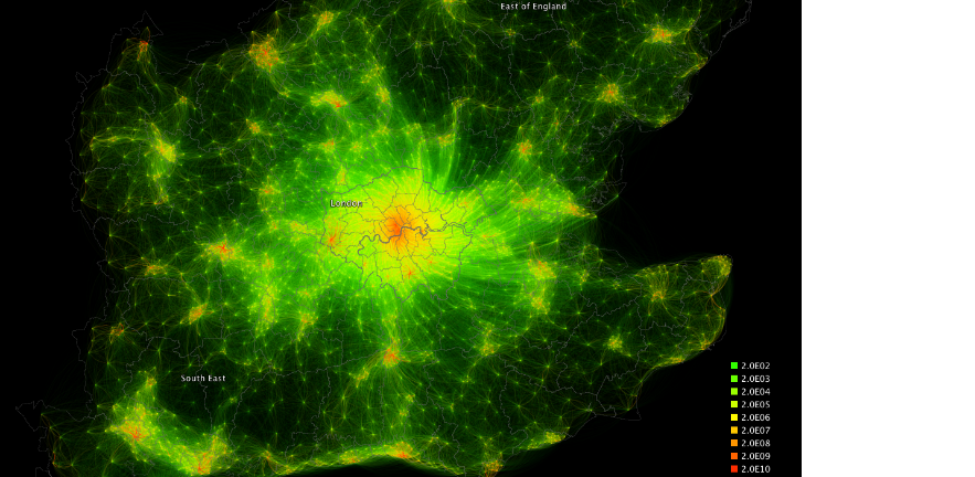
CSIC’s adaptive zoning approach translates location choice problems, which typically scale by the number of locations squared, into ones of near-linear scalability. Testing on adaptive zoning models of home-to-work trips in Southern England (with 3,250 job and home zones) suggests our technique can be as precise as existing methods with one tenth of computational time and memory. This step change from existing modelling suites provides a new way to exploit increasing granularity in data on how people choose where to work, live, shop or spend leisure time, and produces more precise simulation of the effects of policy interventions.
Impact and benefits
CSIC’s new adaptive zoning method:
- Enhances spatial economic and transport modelling, making it possible to model in much higher spatial resolutions, while allowing a radically expanded study area and new geo-datasets
- develops significantly more realistic scenarios and produces outputs in a fraction of the time compared with existing models
- opens a new pathway towards cloud-based computing for model applications involving micro-agents.
Download the full case study here